
Three street reconstruction projects are underway in Downtown Denver. Here’s a quick look at these civic investments—two of which will greatly enhance the pedestrian environment in the vicinity.
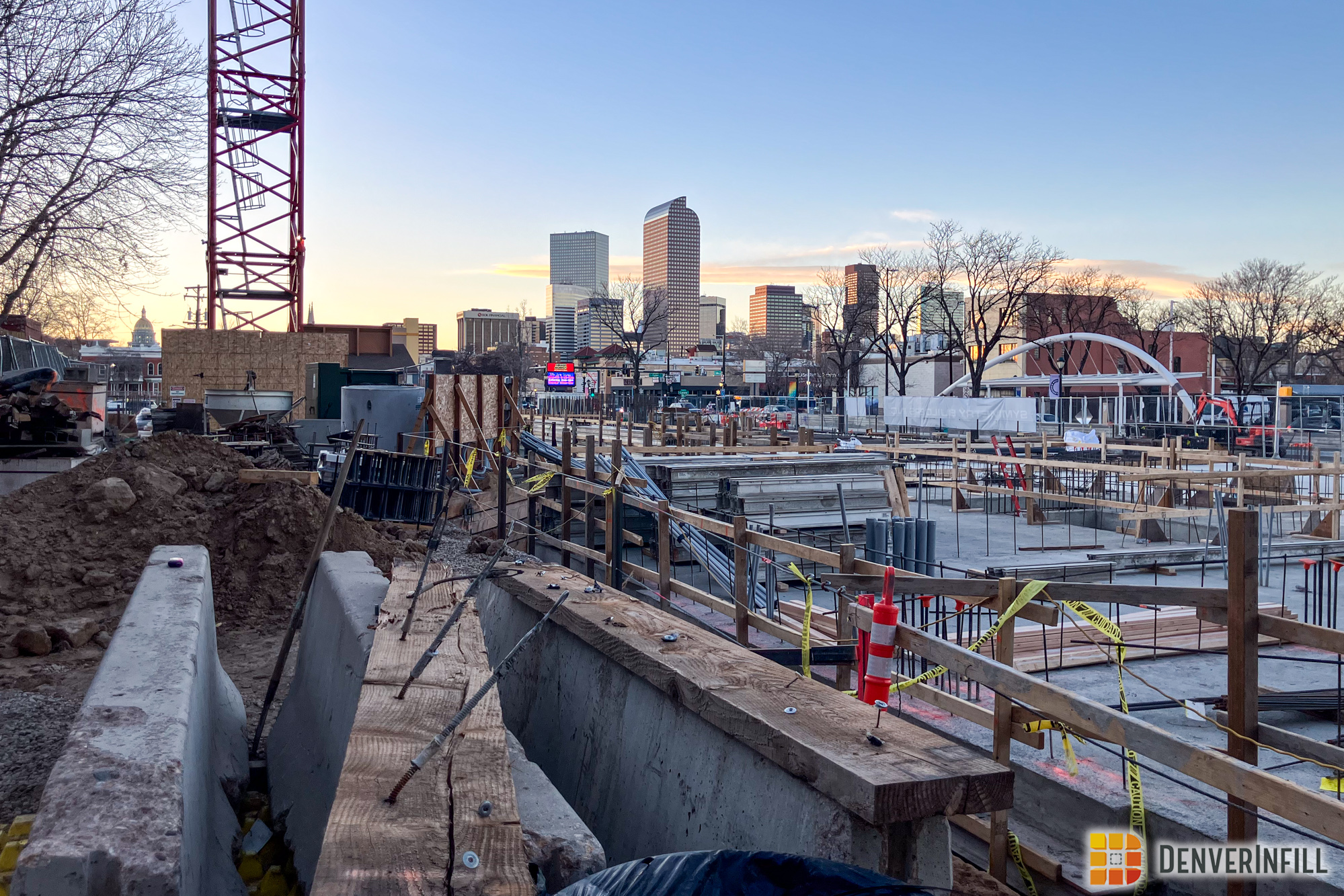
First, let’s start with the one that is a straight-forward street reconstruction project. 15th Street is being rebuilt in concrete between the bridge over the South Platte River and the intersection of 15th/29th/Boulder/Umatilla (one of those fun grid-colliding Downtown intersections). As a Lower Highland resident, I can vouch for the fact that 15th Street through there, particularly around the Platte Street intersection, has been a bumpy ride for years. The street reconstruction is about 50% complete, as you can see from these photos:


Next is Larimer Street between 15th and 17th. This project includes reconstructing the street in concrete (from the current asphalt) as well as removing one traffic lane and widening the sidewalk with the reclaimed space. The sidewalk expansion will occur on the Writer Square/Tabor Center side of the block. While the Larimer sides of those two mixed-use complexes are not all that interesting from a pedestrian perspective, they’re more interesting than the Larimer Place/Barclay condo towers on the other side of the street. Bulb-outs (or, if you prefer, bump-outs) will be installed at each intersection, shortening the crosswalk distance across Larimer even more. Currently, Larimer is four through lanes in this area, and at 15th, the left two lanes continue as through lanes into Larimer Square and the right two lanes are right-turn-only lanes onto 15th. After the reconstruction, there will be three through lanes, and at 15th Street the left lane will continue into Larimer Square, the right lane will be right-turn-only onto 15th, and the center lane will be a combo through/right-turn lane.


Finally, there’s the Colfax/13th/Tremont intersection. Chris blogged about this project a couple of months ago. That project is now under construction. Here’s a Google Earth aerial of the existing intersection (an automobile-oriented mess) and the diagram Chris provided of the reconfigured, more-pedestrian-friendly, new intersection:

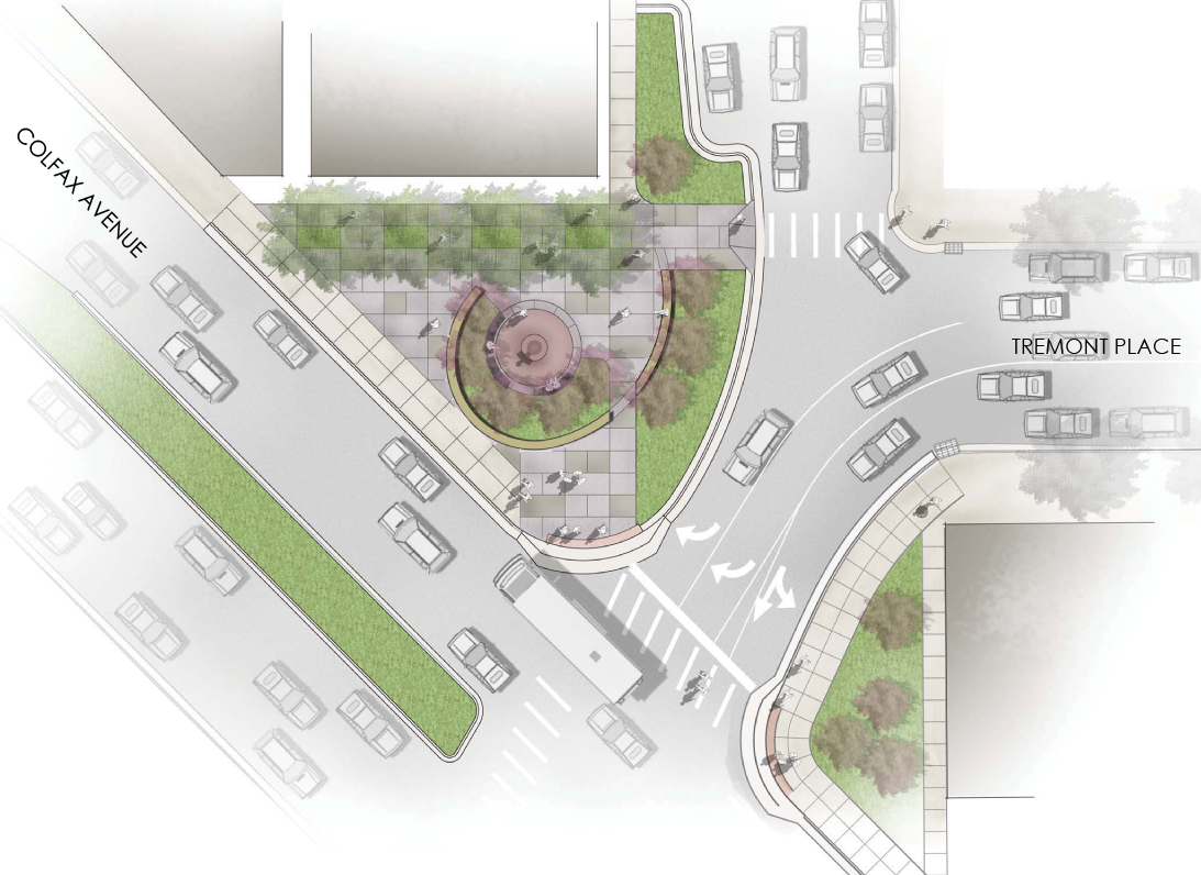
Here’s a photo of the corner I took this morning:

There are more infrastructure improvements planned for the Downtown area coming up… topics for future blogs.


Any word on the 14th street re-do?
Yep, it’s all approved, design work is well along, and construction should begin this fall.
This won’t do anything to improve the sidewalks on the bridges, will it?
No, but CDOT does have plans to rebuild the 15th Street bridge sometime within the next 5-10 years so when that happens, it will have a substantial pedestrian component. Can’t see the bridge over the river getting rebuilt unless it’s structurally poor. ?
15th street is an important connection between lohi and lodo. it is marked as a bicycle route on the b-cycle map but cars move incredibly fast there. it is too bad that with the reconstruction one lane couldn’t have been designated as a protected bike path. was this even considered?
Another small victory for the pedestrian!
Ken,
Now that Larimer is being redone, will there be any trees planted on the expanded sidewalk?
I believe the project includes new streetscape that most likely includes trees where there are none now.
15th St is an important connection between lohi and lodo. It is marked as a bicycle route on the b-cycle map but cars drive very fast there. Since it is being reconstructed, was it ever considered to build a protected bikeway on this street?
The green coloring makes the intersection more appealing already. Too bad the city will inevitably let it turn to weeds. See former grass near I-25 / Alameda, I-25 & 6th for examples of ruining an investment.
This is a very different kind of space than the hard-to-reach areas in the interchanges of I-25 are, and I don’t think you can make accurate speculations by comparing the two. Also, I think this space would be managed by an entirely different government, since highways are CDOT and this would be City and County of Denver related.
I heard a rumor through the grape vine that the 14th Street Improvements have been substantially reduced (at least the aesthetic parts) due to unexpected utility costs. Therefore, the final product will look different than the renderings we have seen. Has anyone else heard anything about this? It could just be speculation but my source is usually pretty accurate so I thought it is worth bringing up.
Mentioned earlier in the comment thread… I’d love to see something happen with the bridge over the highway… Seems like a great op to expand pedestrian travel.. add a bike lane.. etc. Surprised those “hand rails” are even up still — heavy rusting, super low, sketchy.
I think 15th is a perfect street car st as well. Direct from Downtown into the Highlands.
One can only dream.
Ken,
The DBJ seems to have a story on the fate of the revamp 16th street mall and doesn’t look good.
http://denver.bizjournals.com/denver/stories/2010/07/19/daily87.html?surround=lfn
All those years of study and they are planning on keeping the same design? Say it ain’t so! I guess we’ll find out on Aug 11th.