
Everyone is certainly aware of FasTracks, metro Denver’s rail transit expansion program approved by voters in 2004 that will add 119 miles to our existing 35-mile rail system and position Denver as one of the nation’s leading cities in public transport. Based on a hub-and-spoke model, RTD’s post-FasTracks rail system will be well suited to shuttle passengers back and forth from Downtown Denver to the city’s outlying suburbs, DIA, and Boulder. It’s necessary, and I’m happy we’re doing it.
But, the time has come for Denver to invest in rail transit for its urban core. RTD’s post-FasTracks system will provide minimal utility to the 205,000 people who live within a three-mile radius of Downtown. Much of the RTD system runs along freight rail corridors and through industrial areas, not where Denver’s urban core population resides. Denver’s center city is well-served by bus routes, but busses can get stuck in traffic or stuck in snow, and they don’t provide the same quality transit experience that can be provided by streetcars. Because of the permanent infrastructure of streetcars versus the transiency of a bus line, streetcars can also stimulate economic development activity to a far greater degree than can bus routes. Streetcars are also more conducive to denser urban environments as they typically share a travel lane with vehicular traffic, as opposed to light rail, which typically runs in its own right-of-way. Here’s an example of a streetcar line in Portland, Oregon:

Denver once had one of the most extensive streetcar networks in the country. Denver’s system, which first started in the 1870s as horse-drawn streetcars, evolved into a fully electrified system that provided service to virtually every developed neighborhood in the city by the 1920s and 1930s. Of course, you can probably guess the rest of the story: by the 1940s we started replacing the streetcars with busses and, in June 1950, the last streetcar made its final run in Denver.
Just how extensive was Denver’s streetcar system? Using the Denver Tramway Company streetcar route map included in Robertson’s and Cafky’s tremendous Denver’s Street Railways, Volume II book (published in 2004 by Sundance Publications) as my guide, I’ve created this exhibit showing Denver’s streetcar system as it existed in 1926 (about when the system was at its peak) overlaid on top of a current Denver aerial:
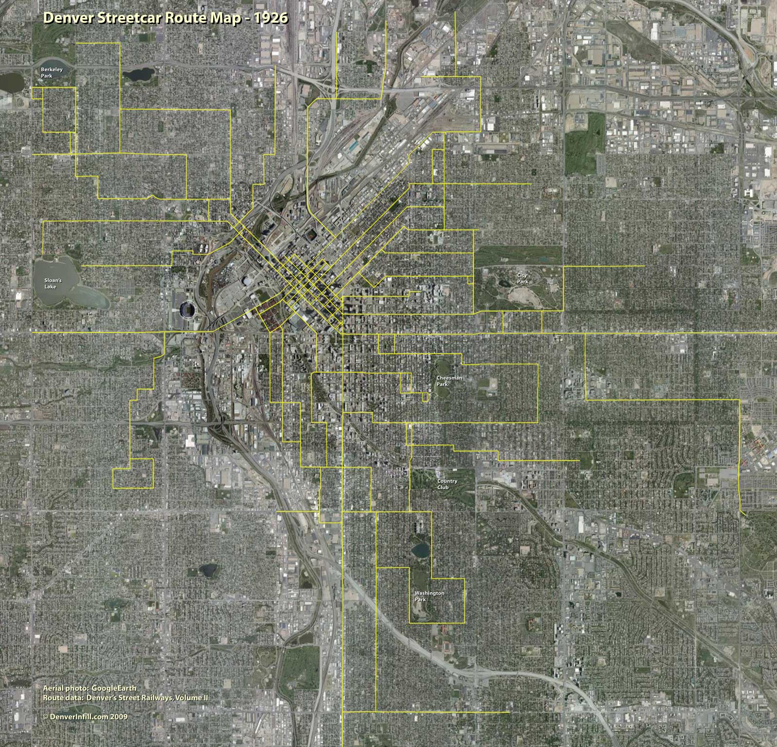
Incredible, huh? Plus, what’s not shown on the map are the “inter-urban” lines that ran to Arvada and Golden.
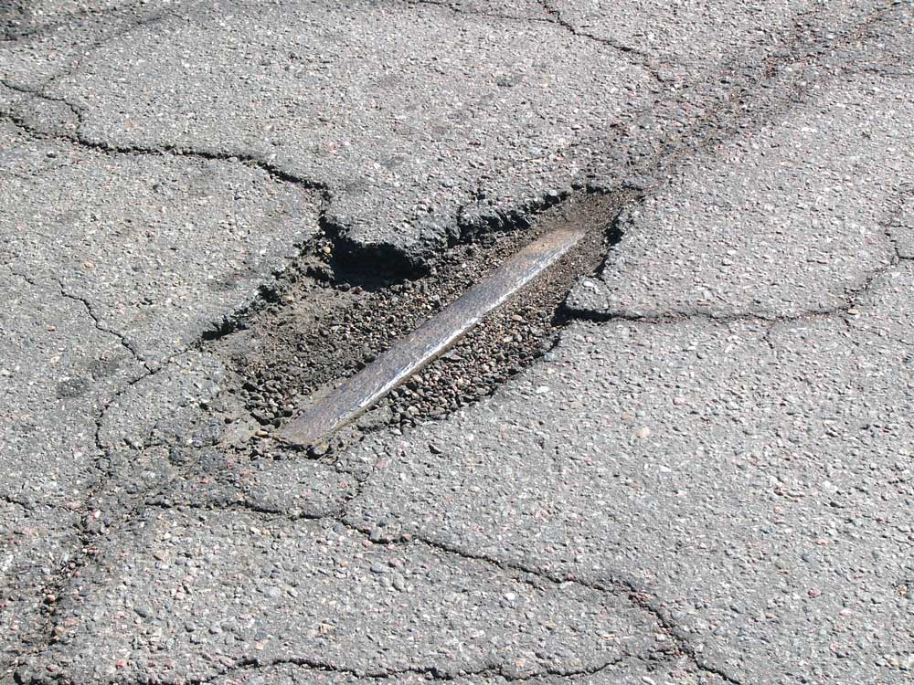
If you look closely, you can still find evidence of Denver’s streetcar system today as, in a number of locations, the rails were simply paved over and are sometimes visible through the asphalt, like this shot I took a few years ago at 14th and Delaware (I think it’s been paved over since):
So, what we should do is begin laying the foundation for a return to a streetcar system that serves Denver’s urban core districts by creating a Downtown streetcar loop from which additional streetcar lines could eventually radiate to places like Cherry Creek, Highland, Curtis Park, South Broadway, and elsewhere. Converting the proposed Downtown Circulator, which is planned as a mall-shuttle type bus that would travel between Union Station and Civic Center via 18th, 19th, Broadway, and Lincoln, to streetcars would be a good place to start. And like in Portland, our Downtown streetcar loop, along with the 16th Street Mall shuttle—also a potential streetcar conversion opportunity—should be part of a “fareless square” that enables free transit within the Downtown core.
Debating the alignment of the streetcar loop and subsequent extensions is the fun part; getting our first starter line in place will be the challenge. I’m convinced that RTD and suburban voters will not be in the mood to fund a Denver-centric streetcar system anytime soon. Consequently, if an urban core streetcar system is something Denver citizens want, then we’re going to have to pay for it ourselves. A couple-hundred-million-dollar bond issue and a 0.1% sales tax increase would probably get us started.


if we're going a starter line, and if all we can do is one, colfax from DT to Fitzsimmons would have to be a good place to start.
A second great starter line would be from auraria to 40th street via larimer.
another thought…more evidence of the once great system that denver had? some of our mega-wide neighborhood streets are a result of having rail lines down the middle.
see curtis, 23rd ave, 13th ave and broadwa for examples.
A streetcar line along Downing street from DU, past Washington Park, ending at the 40/40 Fastracks station would be awesome. It is interesting how streetcars are so more appealing than buses.
Out Colfax in each direction would be great. Alameda…Broadway…University…the list goes on.
oh please.. oh please.. I would love to see street cars in Denver – and would pay the tax to do so!! Colfax and Broadway would be the main north/south – east/west corridors in addition to circulators running around DT. How cool would it be to see street cars dropping people off at Coors, Pepsi, and Invesco?
Though I am not one for higher taxes, I would gladly pay an increase if Denver could get street cars. The only thing more frustrating than having the government take your money is sitting in traffic, finding parking, filling up with gas, etc.
Getting the first one done won't be a problem. The first one will be the extension from 30th/Welton along Downing to intersect with the Commuter Rail at 38th, paid for with FasTracks money. This will be a good one to build off from — either back along Downing south, or to points north and west from 38th.
(This will use existing tracks on Welton and in the downtown loop, returning back to Welton and then Downing after looping around downtown in front of the convention center.)
Getting the first one done that is not paid for with FasTracks money will be the trick. As you say, Denver folks will have to get the vision and pay for it, rather than it being paid for RTD-system-wide.
I would like to see a way to get from DT to Cherry Creek, SE Line to Cherry Creek (and north until at least the zoo/museum area), and LA/Pearl to Wash Park. A line down Colfax and another down Broadway would make sense. Up into the highlands to highland square would too.
Yes! I live off E Colfax and that street just screams streetcar. I also think linking Cherry Creek to downtown is critical. I don't own a car and sadly I just find it more convenient to ride my bike than rely on current mass transit.
Portland and Seattle's new streetcars are really cool. I'm told the Czech trains both cities used are significantly less expensive to install and run than light rail.
Ken, I hope you're planning to cull your "top ten" posts into a single page somewhere on the DenverInfill site. A link to that page would be extremely useful.
I'm sure that Denver residents would be happy to pass a <1% sales tax increase for streetcars in almost any economic climate. We could accomplish much within our city limits. Cherry Creek North and Downtown both would benefit from being connected. And our share of Colfax is, what, 8 miles? Let's do this.
I agree that streetcars in Denver would be great. I will point out, though, that depending on how you build them, streetcars can get struck in traffic. The ones in Portland do.
Anonymous said:
"…from auraria to 40th street via larimer."
That would be great for not only connecting Auraria to Downtown, but also getting movement into and through the "Ballpark" area, which is a greatly underutilized part of core downtown.
The recently-adopted Downtown Area Plan shows a notional transit line like this, which is an excellent official expression of interest in this by the City.
It should, quite naturally, connect up with the streetcar at 38th/Blake where the Downing streetcar line will end. (Actually the entire run should be one "line" making an inverted-U up from downtown, around Curtis Park on Downing, then back down via one of several possible routes through Ballpark through to Auraria.
I agree with those who say the downtown to Cherry Creek line would be a critical one in a streetcar system's early days–it would reduce traffic and get more people using transportation. My route:
Start at the Glendale SuperTarget.
West on Alameda/Cherry Creek Drive/Steel/First/Speer.
Down Speer to Downing; turn right and proceed to the Capitol Hill King Soopers. Left onto 9th Avenue; west on 9th to Ogden. Right on Ogden to 11th. Left on 11th, and then west to Lincoln. Right on Lincoln and then connecting to the downtown circulator.
–historymystery
I believe the just-published Denver Strategic Transportation Plan identified real congestion problems in its travel-shed analysis for Speer. This can be referenced in discussions about a streetcar as an alternative to single-occupancy private vehicles along this important route.
Your your arguments about the advantages of streetcars over buses aren't terribly convincing. How is it that streetcars, which share the right-of-way with cars, could avoid getting stuck in traffic? Also, I can't think of the last time I was on a bus that got stuck in snow. Where is the evidence for your assertion that permanent infrastructure would encourage development (especially on the first route you're advocating, which seems pretty developed already).
For purely selfish reasons, I would run the 15th St line through DT west across I-25, go up Zuni, west down 32nd Ave, then run it north up Tennyson. You'd hit three key retail areas, all of which were formed by the streetcar in the first place.
Was there not a line running up Irving north of where Speer runs into it? I'll look for tracks next time I'm walking there. I guess it could have gone in after 1926.
the advantage of streetcars is that we can have good 'through-routes'….
i've always thought that a 40th street, larimer, speer, 1st, colo blvd would be a great route connecting LRT stations on either end and serving much of the city, campuses, shopping areas etc.
Denver's first traffic engineer, Henry Barnes, had this to say about streetcars: "I often said I didn’t mind street cars except for the fact that they ran on the street." Maybe that's part of the reason we don't have them any more.
There's more about Henry Barnes (and the barnes dance) at buckfifty.org.
Gabe, whenever you hear the assertion that streetcars encourage more private investment than bus lines, the basis for that is almost always the Portland Streetcar system, which claims to have encouraged billions of dollars in private development along its routes.
Andy, streetcars are indeed cheaper per mile than light rail. Much cheaper.
In regards to the congestion issue, streetcars aren't better than buses when it comes to sitting in traffic. However, it would be great to see the streetcars run in dedicated transit lanes that can only be shared with buses, people making turns, and possibly HOV vehicles, at least in certain high-congestion areas such as Broadway. It probably wouldn't make car drivers happy since they would lose a traffic lane, but it would give central Denver quick, reliable transportation for a low cost, and encourage people to leave their cars at home and switch over to transit.
Plus, imagine how predictable the streetcar schedules would be. No more waiting at a bus stop in the cold for a bus that is 20 min behind schedule during rush hour.
It's really just a question of where our priorities are.
You don't have to look at just Portland to find a reasonable claim that street cars act as catalysts for further investment. Europe has had great success with them for years and even a city like SF is renowned for their use of them. In effect, people want to "live/work" within close proximity of these lines since they add an important transportation element, a freedom to travel around with the use of a car. That's a catalyst for investment in infrastructure, such as TOD's. Pardoxically, people don't make the same assumptions about bus travel, which just means more people would be willing to travel by train than by bus. I doubt anyone would argue otherwise.
For practical purposes, I see rail as a great way to move people around the city and to connect neighborhoods. Sure, I ride my bike everywhere, but when it's cold outside and I just want to make it down Colfax for lunch, to do errands, or visit the Tattered cover, I would love the novelty of jumping on a train. Perhaps in the summer, all the windows could be down and you could "experience" the city without feeling couped up inside a vehicle.
it sounds like we have the makings of a resident-driven ballot initiative…anybody interested?
RTD doesn't necessarily have to run this, just need to cooperate where there are shared / nearby station.
I'm interested! Never hurts to throw a little "public weight" around to get things moving…
Unfortunately, Ken is right. A street car system wont be on the table anytime soon. At least until gas prices start rising again, and after Fast Tracks is completed. Also, the population of the urban core, more specifically downtown, needs to be much larger.
More people= more money.
There also needs to be a no-fare zone, and that wont be cheap either.
Gabe,
Sure Streetcars would basically be doing the same thing buses are doing. But the fact of the matter is, Streetcars are way more attractive. And it makes our city look good in the eyes of tourists, investors, and ordinary residents. get the picture?
Of course, the biggest flaw of streetcars/LRT's is the increasing threat of poweroutages which will stop those vehicles dead in their tracks and reek havoc on the entire system, and make many riders stranded and unhappy.
In the meantime, we can all blame GM for the disappearance of streetcar systems across the country: http://www.youtube.com/watch?v=wFhsrbtQObI
I love street cars. Colfax and Broadway require and need streetcars now. These are the closet to do-able now.
The biggest problem with buses is how we have implemented the routes and stops. As public transit has been extremely squeezed the last 60 years, the main customers have become the poor and the elderly. Two situations have come about: 1) we cater to bus stops 2 blocks from each other 2) we have routes that are too stretched. They don't have logical sense except to cover as much territory with the least amount resource.
Routes are slow, and they are on a time table so they can never go faster.
If want to improve our transit for people other than commuters, bus routes need to be changed: Circular routes (ala streetcar) Looser but more predictable schedule: like :30 and :00.. or every 5 mins during 7-9.. etc.. most importantly bus stops every 4 blocks, the exception would be for elderly (who sit at the front anyway) can request a stop exactly where they want. That's power to the people.
In addition to the TOD issue, streecars as compared to buses are more comfortable to ride, have higher rider capacity, attract more riders, and are cheaper to operate on high-ridership routes.
The comfort issue is a big one, by the way. Buses are incredibly bumpy. It's very easy to get motion sick on a bus. Trains are much smoother. This is not a frequently talked-about issue, but it is a BIG one. Probably the biggest reason why buses have the negative public connotation they do.
And for the record, there is nothing that says streetcars have to operate in mixed traffic. You can put them in their own lane. The Five Points section of Denver's LRT is basically a streetcar.
This is why GM shouldn't get a bailout.
http://en.wikipedia.org/wiki/Great_American_streetcar_scandal
I could not agree more!!! Streetcars would be an incredible addition to the downtown core!
What an awesome way to bring some nostalgia back to all of this concrete!
I respect that this was posted from this site, but I recognize that this plan is great.
https://denverinfill.com/streetcar/index.html