
As construction on the West Corridor nears the halfway mark (completion is expected in May 2013), I thought it’d be a good idea to check out progress along the first FasTracks corridor. Much of the construction (with the obvious exception of the work along 6th Avenue) is taking place in existing neighborhoods, usually not too noticeable from nearby thoroughfares. The 12.1-mile light rail corridor will have 12 new stations (with 4,959 new parking spaces), and offer 5 minute peak period headways from the Federal Center to Denver Union Station (DUS) and 15 minute peak/offpeak headways from the Jefferson County Government Center to DUS.

We’ll take a look at the West Corridor in 3 zones. Zone 1 spans from DUS to the Sheridan Station. Zone 2 goes from Sheridan to the Denver Federal Center Station, and Zone 3 travels from the Federal Center to the Jefferson County Government Center end-of-line station. Today, we’ll look at Zone 1.
Rick is doing an awesome job keeping us up to date on all that’s going at DUS, so I won’t touch on that other than to say that the West Corridor will start at the new light rail station along the Consolidated Mainline (CML) tracks. From there, the corridor will follow the existing Central Platte Valley (CPV) spur through the Pepsi Center/Elitch Gardens and Invesco Field at Mile High stations. The only changes anyone will see at these two stations will be an extension of the platforms to service four car trains. Platforms along the Central and Southwest Corridors will all be extended to offer four car train service – the Southeast Corridor platforms were constructed long enough for four car trains. The West Corridor (and subsequently the I-225 Corridor) will be constructed to a four car length as well.
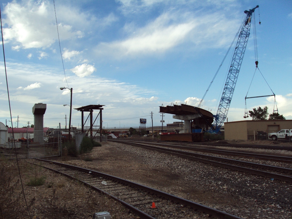
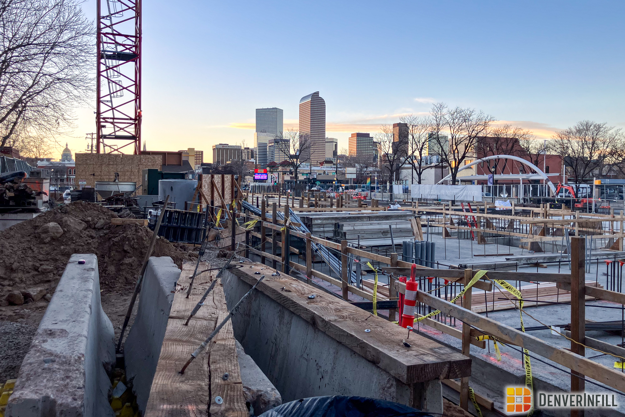
The Auraria West Station will be moved about 400 feet west of its current location to realign for the bridge over the Burnham Yard lead freight tracks. As you can see below, construction on the new station is well underway.

From the Auraria West Station, trains heading south will stick to the east and travel towards the existing Colfax Junction. However, trains heading west will travel underneath the Colfax viaduct, climb onto a large bridge over the CML tracks and over Umatilla, then move underneath I-25 just north of 13th Avenue. Crews have started placing massive steel girders along the 770 foot, double track bridge. The bridge is designed with a 300 foot radius, requiring the light rail trains to slow to a maximum of 20 mph. Curved bridges tend to want to twist between supports as trains pass over, so a system of cross frames and bottom-flange lateral bracing was used to stiffen the bridge and help transfer loads. There are five spans, the longest reaching 180 feet. The bridge will require 60,000 cubic feet of concrete and 400,000 pounds of reinforcing steel. The bridge, when complete, will weigh 9.4 million pounds.

The tracks will then travel over the Platte River just north of the power plant and south of the Denver Public Works facility at Decatur and Howard. The Decatur Station will be located just south of 14th Avenue between Federal and Decatur. Crews have already completed the bus bays for the future station and are storing other construction materials on site.


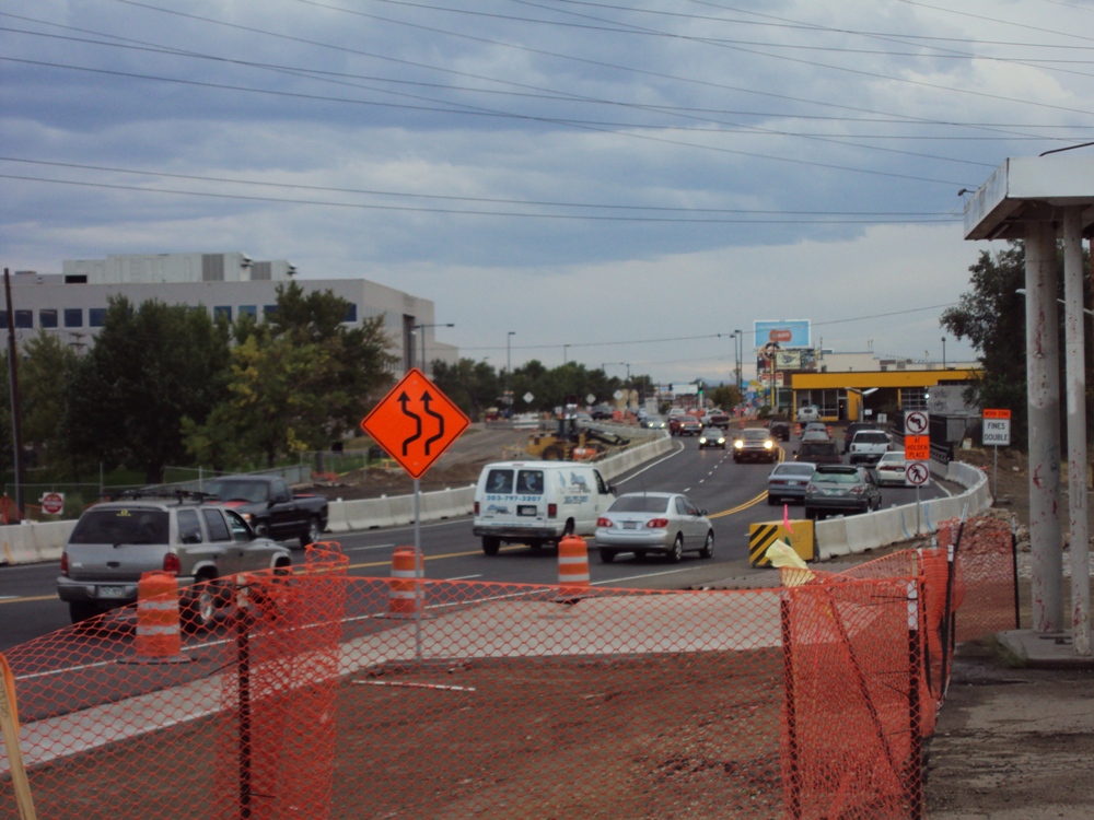
As part of the West Corridor project, the Federal Boulevard bridge is being reconstructed for the Colorado Department of Transportation. The bridge was one of the worst in the entire state, rating only a 4 on a scale of 100. The girders used on the new bridge are pre-stressed to handle 50 million pounds of force. The new bridge will be 119 feet wide, enough for three lanes of traffic in each direction and a southbound bus lane. 10 foot sidewalks will also be included on either side of the bridge for bicyclists and pedestrians. The new three-span bridge will weigh 8.5 million pounds. Both directions of Federal were recently moved onto the new southbound section while demolition and subsequent construction of the northbound span gets underway. The pictures below show the contrast between the new southbound span and the old northbound span.


There are three pedestrian bridges along this section of the corridor as well, helping nearby residents cross over the tracks as well as the Lakewood Dry Gulch. The bridges are at Wolff Street, Hazel Court, and Tennyson Street. The Hazel Court bridge will be site of a celebration next Wednesday to mark the halfway point in West Corridor construction.

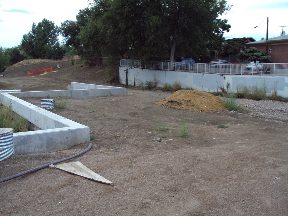
The Knox Station is under construction after a major reconstruction of Knox Court over Lakewood Gulch. The old box culvert (with just one opening) was replaced with a three-box culvert to allow more water to flow unobstructed under the street during major storms. There was a lot of water flow mitigation work to be done in this section of the corridor. The station will not have any parking, but you can see the bus pullouts have been completed already.


The Perry Station is also under construction – although no bus facility will be in place at this station. Some of the longest retaining wall sections are located near this station, as is the Tennyson Pedestrian Bridge, which you can see in the distance.


That’s it for the Denver portion of the West Corridor. Next post, we’ll start off at Sheridan (actually the Denver/Lakewood boundary) and head further west. For more information on FasTracks and the West Corridor, check out www.rtd-fastracks.com.


Thank you for all of your hard work in putting together this very nice update! It’s nice to see that Fastracks is moving along in these hard times.
Btw, Google Earth just updated the Denver area satellite imagery to June 2010. It’s amazing how much has changed within the last 3 years!
Thanks for the compliment and heads up on Google Earth – I hadn’t noticed that!
Thanks for the info and pictures I need somewhere to get my transportation fix after Kevin Flynn took a job with RTD.
Just one request though if theirs anyway you can post smaller or lower resolution pictures next time. It’s killing the load time for the main page and this page and I have a very good internet connection.
I’m resizing the photos right now – I’m so sorry! I didn’t check it when I uploaded them. Apologies again!
Looking forward to the updates as you travel west. This is an awesome blog and agree with Aaron’s comments as well.
Also, any news on 16th street mall configuration… I heard a direction with this decision was in the works.
I was surprised to see recently that the west line is not going all the way into downtown golden. How is it that suburbs like lone tree get a light rail station, but golden, which has reasonable density and attractions to warrant a station is left out? Is this due to money or right of way access or something else?
The Gold Line Major Investment Study (MIS) was completed by RTD is the late 90s/early 2000s – that corridor would service Downtown Golden. The West Corridor was never planned to extend that far – from what I’ve heard, the section from the Fed Center to the Jeffco Courthouse barely met the required cost/benefit analysis completed by RTD for the Feds. RTD reached an agreement with the BNSF railroad in March and purchased the right-of-way into Downtown Golden (along with other ROW segments for the eagle project. I’d assume that an extension to Golden will be a long-term plan, but it’s definitely something RTD is considering and will most likely do at some point in the future.
that’s a shame considering the courthouse is so close to downtown golden. i wonder how the extension would fair under the new federal funding guidelines- http://www.dot.gov/affairs/2009/fta0110.htm
By the time that the currently planned light rail projects are finished so that extensions can be considered and added, gas prices will probably be so much higher, and urban densities will probably be so much higher that by then the cost/benefit numbers will probably work out.
I read an article in the Wheat Ridge paper that the Gold Line is going to stop at Old Town Arvada and not at Ward Road in Wheat Ridge. Does anyone know if this is true? If they ever extend the Gold Line into downtown Golden they will hopefully do something about the horrible stench of the sewage treatment plant along Clear Creek. You would think that some day there should be the technology to drastically reduce the odor from these facilities.
There must have been some kind of a mistake in the Wheat Ridge paper – the Gold Line WILL stop at the Ward Station. That’ll be it’s end of line station.
I agree with you on the sewer treatment plant too….yuck. Maybe we can all purhcase air fresheners and place them around that plant.
Ryan, perhaps you could investigate and comment on why this line will take so long to complete from now. May 2013 is over 2.5 years from now. I have monitored the progress of the West line very closely over the past year. They have made tremendous progress, and I figure at this rate they should be nearly complete with all construction – rails, stations, and all – in no more than a year and a half. What could possibly take an additional year? Remember that the Southeast line was completed in 2.5 years in the middle of TREX construction. I would find it hard to believe that the contractors need so much additional time, so I suspect some other reason. If this line opened in early 2012, it would start generating revenue to pay for itself that much earlier!
I’ll look into it Dan – look for something in one the my next West Corridor posts.
My rule of thumb for construction projects is that they are half way done when they look practically complete from the outside to a casual observer.
Since the West line is mostly not in the middle of a busy highway that is also under construction, and since RTD’s tax revenues are coming in later rather than sooner, I wouldn’t be surprised if the pressure to push against deadlines and work 24/7 is a lot less intense than it was during TREX.
Denver’s light rail system was never designed with an intent to pay for capital construction costs out of operating revenues and never will. There isn’t a single route in the entire RTD system the even makes even an operating profit, although the Colfax and Broadway routes and (ironically) the free Mall Shuttle have very low subsidies per passenger mile and could be made profitable if one had a mind to do so.
Capital costs for this project, IIRC, come 80% from the feds and 20% from local funds mostly generated through an additional sales tax levy in RTD’s territory.
Great post! It’s very interesting to see the other parts of this project that aren’t visible from major roads. Thanks!
Thanks for the Golden explanation. I, too, wondered why the west line didn’t extend into downtown Golden. That’s about the only suburban location worth traveling to via light rail (I’ll give downtown Littleton a nod, too.) I just hope that whenever the Gold line is extended that the Golden station will actually be near downtown and not near some industrial slag heap….
I think Boulder tops the list of destinations outside of downtown Denver.
Perhaps the extra time required is for testing. I remember the others were all completed for some time before actual passengers rode on the lines.
Just out of curiosity, why are they not planning on looping West Line trains through the CBD California/Stout Loop? Seems to me that even two or three going to that end of downtown during the morning and evening rush would be a nice feature for a lot of commuters.
All trains on the West Corridor will route through DUS only, largely because during peak times, the California/ Stout loop is at capacity already. Also, who additionally would ride the West Corridor daily from central downtown that wouldn’t ride to Union Station? The Free Mall Ride does a pretty good job connecting the two.
Lets say I visit Denver in May of 2013 and I want to ride the West Corridor. I’d start out at Dayton Station, ride the H line to Broadway, change to a C or E line train, ride to Auraria-West, change again to the “B” line (I think), and ride the W.C. and back. Thats fine for me, but not necessarily practical for the daily commuter.
But I agree, due to potential ridership increase, infrastructure issues, and costs – probably the best way to do it.