The original DenverInfill website included Downtown-area infill projects planned or built between January 1, 2000 and December 31, 2009—one complete decade. Since the start of 2010, all infill project-tracking and reporting duties have been handled exclusively here on the DenverInfill Blog (launched on July 5, 2005). With 2014 over, that means we now have fifteen years’ worth of projects we’ve been covering at DenverInfill!
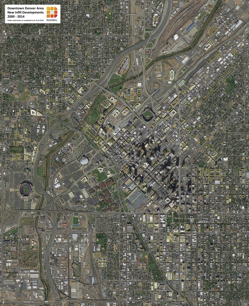
To celebrate this milestone, I decided to prepare a graphic showing the footprint of all (or mostly all) of the infill projects in the Downtown Denver area that were completed between January 1, 2000 and December 31, 2014 or are currently under construction. Click on the image below to view at full size, or click here for a huge version in PDF format.
A few notes about the image: The boundaries are Federal Boulevard on the west, Downing Street on the east, and 6th Avenue on the south. To the north, it goes just far enough to pick up the River North district below 38th Street. Proposed projects are not shown, nor are any adaptive reuse or historic preservation projects. Also, there are dozens of townhome projects that are not shown. I’ve included a few, but there are so many of these smaller (say, under twenty units or so) townhome projects being built in the downtown fringe areas that to attempt to capture them all was simply beyond the scope of this effort. This graphic is meant to be fun and interesting to look at and offers a broad 30,000-foot view (actually, 13,000-foot view according to Google Earth) of the magnitude of infill development in the Downtown Denver area in the past fifteen years. If I missed a few projects, don’t sweat it. This wasn’t meant to be a complete and accurate survey.
There are 305 projects shown. My very rough estimate is that they cover approximately 8 million square feet of ground or about 180 acres or 70 city blocks. By land use, they represent approximately 18,000 residential units, about 7 million square feet of office/commercial space and about 2 million square feet of civic/cultural/educational uses.
What I want you to take from this graphic is how far we have come as a community in repairing the urban fabric of our city center. One hundred years ago, a vacant or undeveloped parcel was a very rare thing in the Downtown area, and there were absolutely no surface parking lots. Downtown Denver in 1915 had a virtually complete urban fabric: blocks of buildings defined and separated by streets, streets defined and framed by blocks of buildings—the quintessential urban form of cities for millennia. This urban fabric was nearly decimated in the post-War era due to a combination of short-term land speculation, ill-conceived urban renewal programs, and a society obsessed with making it as easy and convenient as possible for everyone to drive their personal automobile anywhere at any time.
These infill projects represent our efforts to, essentially, restore the urban form of Downtown Denver of 1915. There are minor differences between the 1915 urban form and what we’re building in 2015 (today, mostly taller buildings and larger building footprints), but the basic form is the same: buildings that touch the property line, have (hopefully) good sidewalk appeal, and frame the street as a public space. A building’s urban form, street frontage, and spatial relationship to its neighbors, is more important to the overall vitality and success of an urban area than what the building “looks like” architecturally. That’s why our emphasis here at DenverInfill has always been about rebuilding central Denver’s urban fabric through infill development to create great streets and public spaces that bring people together and make them glad they’re in the Mile High City.
Happy 2015 Denver!


Ken, a wonderful overview, your constructed “pixels” the fabric of our city! Thank you for showing us how to see Denver as an organic streetscape — with the infill of surface parking lots as the best standard of urban progress! So much more to come…
Great stuff! Denver has come a long way in 15 years and still much to be done(I’m looking at you Arapahoe Square). Here’s to a fantastic 2015 in development news!
You guys have created a great forum to not only demonstrate what is happening within Denver, but teach why it’s important. Better informed citizens will make better informed decisions. Great job on what you’ve accomplished and looking forward to seeing what’s around the corner. And now that we actually have buildings on many of our corners, that pun actually makes sense!
Thanks so much to you, Ken, for creating and promoting this wonderful blog/website and also to the City of Denver and the private sector for making this massive change happen! I look forward to what we’ll see in the next 15 years 🙂
Great observations Ken. I would like to add that Denver is also emerging from average city status to great city status as a result of this development (or it could also be claimed that the development is a result of recognition of Denver’s potential). As a 63 year-old native who traveled extensively in the US and internationally, I recognize that Denver is now taking on features that make cities great. As you point out, one feature is a dense yet diverse and livable and appealing urban physical fabric. So many cities are places that thrive during the business day and die at night. Denver thrives all day and on weekends – people actually leave the ‘burb’s to recreate in the city center. But I also have observed that even the ‘burb’s seem to have been energized by this urban renewal with a cleanup of their own. I hope ‘urbanization’ and density infect all front range cities so we stop destroying what we should value the most in the west – our vast and beautiful landscape. To me the most important feature of this trend is density, which implies high rise. When you look at the Denver vista from the south and east where the perspectives are the most broad, it is terrific to see the quantity and dispersion of high rise buildings.
Wow! This map really brings home how far Denver has come in the last 15 years. It’s amazing how much has been invested in the city center. I left Denver for San Francisco 15 years ago so I could live in a dense urban city…so I could live in a place where I actually feel the energy of the city as I walk down the street…and to live in a place in which I have no need for a car if I don’t want one. And I truly love it here. But I always hoped to return to my home town one day. And with each passing year, I feel like such a move is more and more imminent (rail transit within the city would be the clincher!).
I’m very proud of what is happening in Denver. And as a 15 year fan of Denver Infill, I am able to keep a connection to Denver as if I never left. I absolutely love this blog!
Thank you Ken, and Ryan, and everyone else who has contributed to this site over the years. It’s an incredible resource and one that I hope is here to stay.
Is anything planned for the two HUGE lots on either side of Market Street between 18th and 19th? Those are screaming for development and yet they remain an ugly blight in a prime area.
Two places under development you might want to check out:
1) Goss Corner at 33rd and Tejon in LoHi. http://gosscorner.com. They are very far along.
2) The old Denver Book Binding location at 2715 17th St in LoHi. They are currently tearing down the old building. No idea what will be going in but it is a big lot.
More info on the old Denver Book Binding location:
http://www.loopnet.com/Listing/18495244/2715-17th-St-Denver-CO/
http://www.loopnet.com/Listing/18495244/2715-17th-St-Denver-CO/