With all the discussion about the City Park View Plane and its impact on development in Upper Downtown, I thought I would elaborate my position on this further.
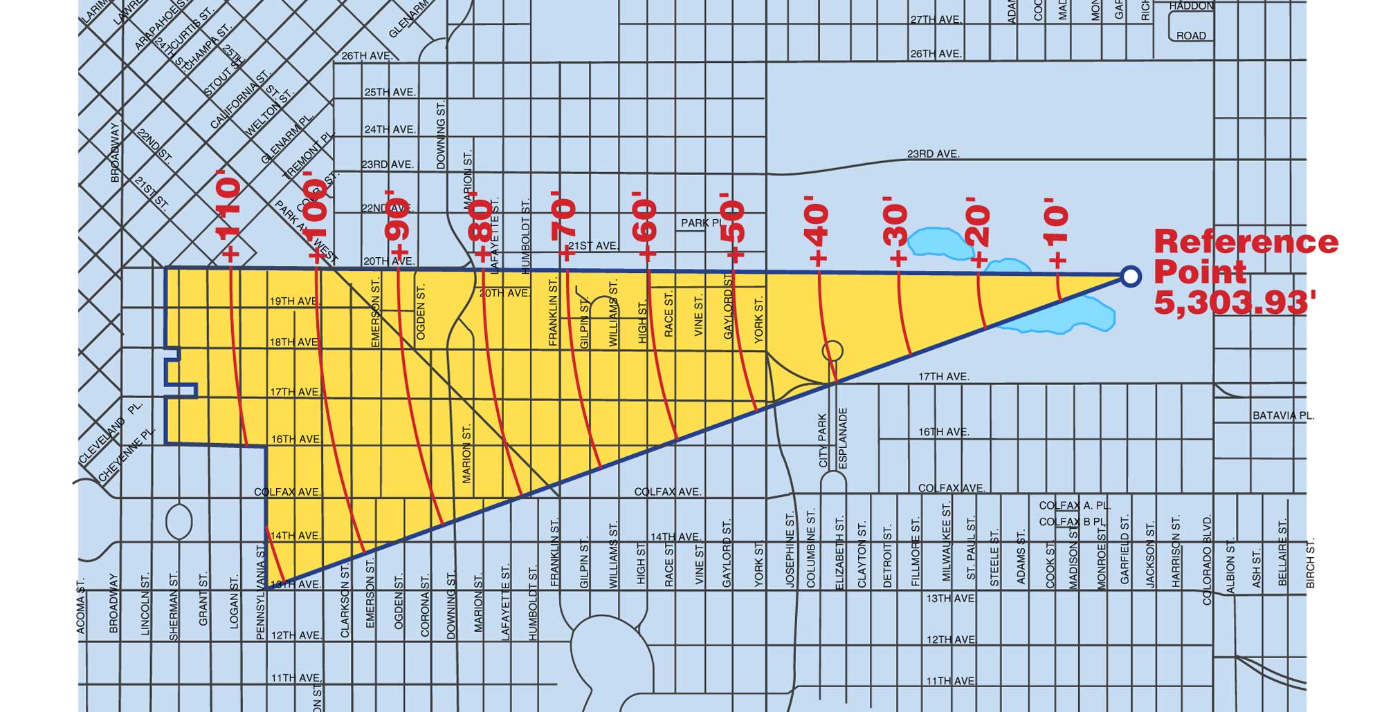
I am not opposed to the City Park View Plane. I am not opposed to the height restrictions it imposes. What I am opposed to is the view plane’s western boundary. Here is a map (courtesy of DenverGov.org) of the City Park View Plane:
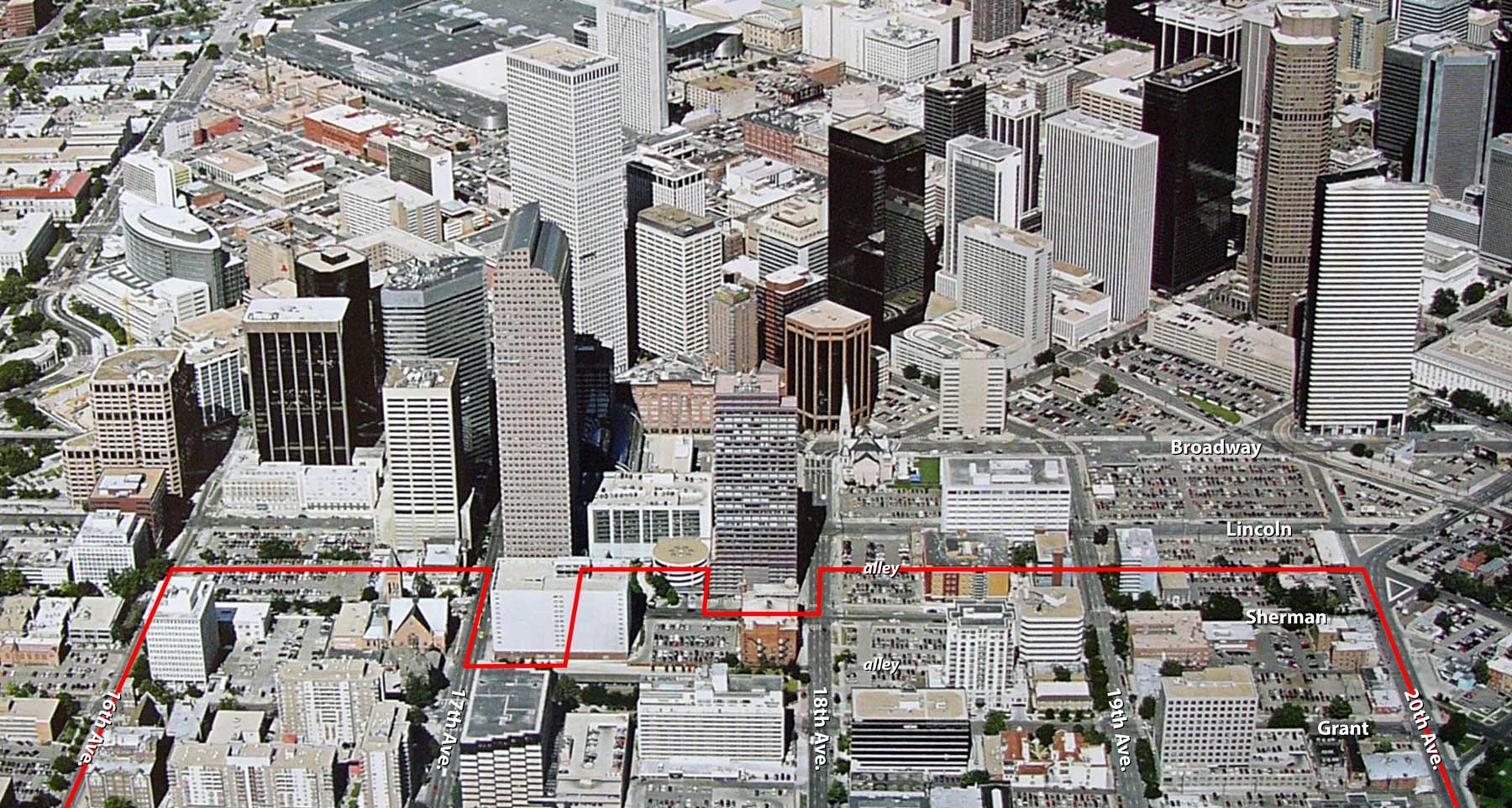
The view plane extends all the way to the alley between Lincoln and Sherman, yet the view plane is intended to protect the view of the mountains and the skyline from City Park. If that is the case, then I argue that Sherman Street is way too close to the skyline to be the western edge of the view plane. In fact, Lincoln and Sherman streets are located within the skyline! With our most iconic tower, the Wells Fargo (Cash Register) building located between those two streets, how could anyone argue otherwise?
Here’s a graphic I put together to show the view plane’s western boundary from a different perspective:
A more reasonable western boundary to the view plane would be Pennsylvania Street, or perhaps Washington Street. That would allow high-rise development to occur along Lincoln, Sherman, Grant, and Logan, which is appropriate given the location and existing conditions, with the view plane then taking effect to allow the skyline to taper down as it heads east into the Uptown district.
The point of the City Park View Plane is to prevent a building from blocking the view of the Downtown skyline with the mountain backdrop, as viewed from the Museum of Nature and Science. Certainly, a tall building built along, say, York Street would block that view and should be prohibited for that reason. But how close to Downtown do you get before a building no longer blocks the view of the skyline, but becomes part of it? Sherman Street is definitely too close; plus, given all the nasty surface parking lots in that area, the last thing we need to do is to discourage development.
I urge the City planning office, Planning Board, and City Council to consider shifting the City Park View Plane’s western boundary to the east by at least two or three blocks.


One thing to consider about the view plane. I think the reference point is on the stairs leading to the western entrance of the museum, not the third floor terrace. Therefore, the tree canopy to the west of the museum, given the current growth, would most likely obscure the view of any building on Sherman Street under 250-275 feet in height.
I mostly agree Ken, but no one told them they could build their building.
In this particular case, a building smaller in height but taking a large footprint does more to help the area than the latter.
Well spoken. If anyone knows how to get a petition going, I'll sign off.
I'd be up to stopping the view plane at Downing. I wouldn't understand anything further.
And does one go about changing such an ordinance, short of magically becomging a part of the Planning Board?
I agree with Ken that the skyline should taper into Uptown. My personal feeling is that a skyline should never abruptly "end" unless forced by a geographical barrier, such as Lake Michigan in Chicago or the Hudson River in New York. The western edge of downtown pushes all the way to the Platte River/I25. A new "edge" is being created along 14th with the Convention Center, the Performing Arts Complex, and Speer forming the boundary. The eastern side however transitions into Uptown, and this should gradually taper away.
You can see on the map that each "ring" of the plane increases by 10 feet. The problem is that it maxes out at around 110-120 feet and immediately gives way to limitless heights. The "Cash Register" is 705 feet tall!
The outer "rings" of the view plane should allow for AT LEAST 400 feet. If they don't, the skyline will always end awkwardly. My personal suggestion would be to leave it the same until Franklin (the 70' ring), but then change each of the following ring's to 100' 200' 300' and 400'. The area past the 400' ring (currently the 110' ring) should be removed from the view plane entirely.
There is a bronze disk in the concrete sidewalk at the top of the stairs at the western entrance to the Museum that marks the start of the view plane.
I could not agree more with this proposal. It makes no sense to push the western edge of the view plane into the business district of downtown. In essence, Pennsylvania/Pearl/Washington mark the western edge of the residential component to Uptown and anything west of that is business/commercial uses with some higher density residential scattered in.
I basically concur as well – although I would say that two things are in play (1) is the view plane issue, (2) the 2nd is creating a meaningful transition into North Capitol Hill with a reasonable edge that respects and reinforces the Capitol Hill neighborhood in its own right – rather than making it a spillover of downtown (which was happening in the 70s and led to the removal of a lot of significant buildings).
Ken's proposed adjustment of the western boundary of the view line accomplishes both.
docroc
i'd say downing is a reasonable location to transition to…just moving back a block or two is a short-term solution that will have us in the same position in a few years – and continue to subject developers to this review board.
I wish that the members City Planning Office, Planning Board, and City Council were regular denverinfill visitors, then maybe they would understand that they are often making terrible decisions. Ken needs to be on one of these boards!
Ken, I think I'm with you on this one.
However, I would like to see a massing of the building in question against the skyline from the point indicated on the first map. I assume (or would hope) that the Board made an attempt to visualize such a massing when they made their decision.
Does anyone from City Council ever read this site? That would be marvelous!
No kidding! But hey, Anon 10:31 has a point. The skyline can't just 'end', as it is already very spread out due to some of those horrific parking lots. Plus, if we want our city to grow and look better, we cannot have some silly ordinance regarding mountain views get in the way. It's impossible to avoid seeing them whilst anywhere on the front range anyway!
city council will NEVER go for this…especially since it goes against the will of very-rich Park Hill residents. the only option is a citizen run ballot initiative…
The skyline can and should "just end." That's what zoning in and around the CBD accomplishes. Height limits vary, by design. And it's a good thing. This ain't Houston! But Ken's point is that the current end point makes no sense. Further, perhaps particular end points should be revisited periodically. Of course, that doesn't mean that the concept of an end point is wrong.
Relax there, Anon 12:27. With the way you hark on my comments, I'm assuming you're either a councilperson yourself or an idealist. One person talking to a councilperson won't do much, and likely the councilperson won't listen to you if they have preconceived notions on the matter. You are only one vote, after all. If the issue can be addressed through a community action group, and then to the councilperson, there might be a bit more of an effect, but then only if that group make up the constituents of the said person's district.
As presented by someone else, the only people who seem to have time for all that are the naysayers. My stake isn't really that high in the matter, since I'm neither a developer or a resident of North Cap or Park Hill, and I've got better things to do like earning money, so I'm relegated to complaining. If a group were to be put together and I were to find out of that group, it'd certainly have my support. But time and bills have funny ways of making people chronic complainers and not activists.
Denver City Council knows and reads all commentary published on the Internetz. In fact, they can read your mind. If you don't believe me, maybe you should send them an e-mail message citing Ken's post.
Ask your district councilmember (or Doug Linkhart or Carol Boigon, the at-large councilmembers) to respond to your concerns. They are incredibly well-versed in the topic of view planes. After all, this is the third view plane dispute that has erupted in the past 12 months — Ruby Hill, Coors Field, now this.
At the time of the Ruby Hill dispute, some councilmembers called for a thorough review of view plane policy before granting waivers for individual cases. Instead, a waiver was granted and a policy review never happened. It's time.
Contact your councilmember:
http://www.denvergov.org/CityCouncil
What, contact City Council? Act like a grown-up? Never. We prefer to complain, then ask what can be done, then (when told) refuse to do anything, then complain more. And the lack of time excuses this juvenile behavior (although we always have time to complain).
Thanks for playing!
Yeah ! This ain't Houston, it's Cowlodaro!
Anon 5:12, I'm wondering how your comment isn't the least bit juvenile? This is a comment board, where we're invited to comment on the situation. All you're doing is whining about us commenting? Are you imagining yourself to be productive?
Well I live in aurora and my view plane is just wonderful! Maybe people who want an unobstructed view of the mountains should move further away from the the downtown area, makes since to me, the city is going to eventually grow beyond its borders here soon anyway. There will probably be a lot more influx of people moving into the dt area here in denver, with the pop. of dt only 2000 ppl. that is by far going to change in the next ten years when we are more business savvy.