

As any regular reader of DenverInfill knows, we have no love for surface parking in our downtown core. Superficially we believe that they are eyesores, but more important than that, we believe that they are underutilized pieces of prime real estate that suck the vitality from what should be the most pedestrian-oriented part of the city. When you have large areas of parking, there is minimal foot traffic and nothing to engage the people on the streets. From the pedestrian’s perspective, it is essentially a wasteland.
Below are a series of images that show just how much land is consumed by surface parking lots and single-use garages. As DenverInfill’s newest contributor, I originally came up with the idea for our 3D Future Skyline feature. Now I have applied the same method to visualize just how much of our central city is consumed by parking.
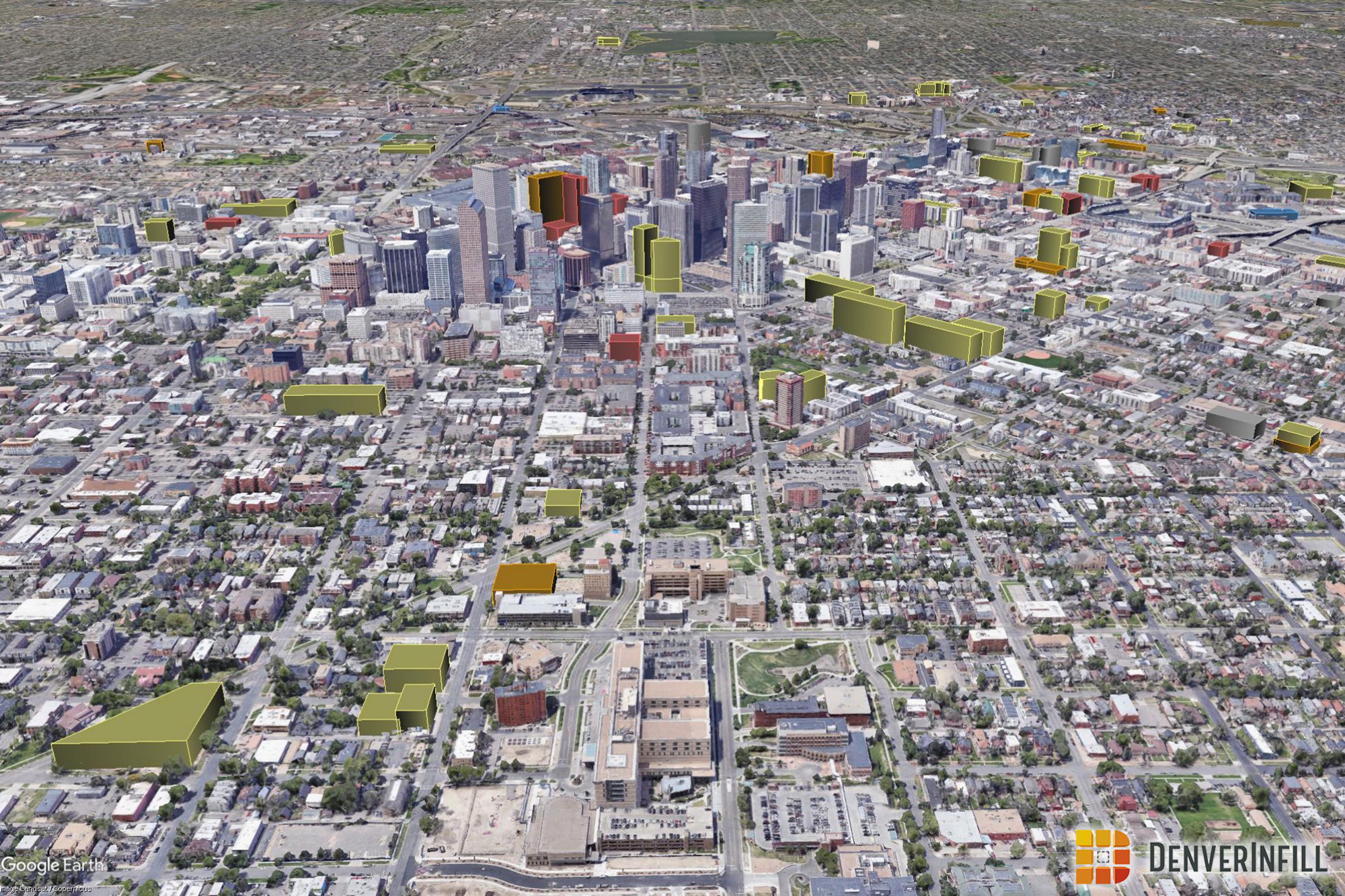
Straight down and north oriented:

Tilted and looking southwest:

Wow, that’s a lot of parking! About 237 acres in fact, and 145 acres not counting the giant lots west of Speer. If it wasn’t clear before, it should now be truly apparent why we celebrate infill development here at DenverInfill. Just about every new building that goes up in downtown replaces a surface parking lot and, in turn, puts more feet on the street and draws more people to downtown. It is by every measure a higher and better use of the land.
While it is clear from these images that there are a ton of these parking craters in our downtown, the city has been making huge progress. Within only the past five years, dozens of surface parking lots have been converted to residences, stores, restaurants, offices, and hotels. DenverInfill is an advocate for this progress and we look forward to the day when all these holes in our urban fabric are repaired.
~~~
Ryan Keeney is a masters student at the University of Denver studying Geographic Information Science, urban form, and multi-modal transportation.


Is that literally half the land area shown? If you include streets, how much car-oriented infrastructure is expected to be supported by what’s left?
The area of interest shown is 1,400 acres, making parking about 17% of the total land area. Now if you throw in on-street parking or even roads then that number would get a lot bigger. Including small single row parking lots, which I did not, would also increase this figure.
Fantastic maps! Though I hate the sobering info, I love having it. This is the best thing you guys have done since the 3D maps. Only way to improve this would be to meld it all and show a time-lapse video of central Denver filling parking lots with new buildings since, say, 2000.
Well done.
Would be interested to see that separating out the surface lots from single use parking structures. Perhaps in yellow and then an orange for “higher density parking.”
This is great Ken. I suggested to you a few months ago that this kind of data should be tracked. This is a great start. I think a development ‘score card’ be used to compare this data about surface lots (development potential) with development accomplished or in process. My guess would be that if we go back 10 years or so ago, we have only developed perhaps 20% of this potential. That is a true infill measurement.
This is a very cool illustration you came up with. I’ve been hearing a lot of stories recently about surface parking lots along both the Speer blvd. corridor downtown and Colfax corridor between Speer & Federal going to undergo massive redevelopment in the next decade that can start making even bigger changes.
I have been a fan of your site along with the knowledgeable content you put into each article dating back to roughly 2005. I go to your site several times a week looking for updates as a Denver native who loves seeing these parking lots disappear. With this post, I have an idea that might be both interesting and potentially useful for people as they plan trips downtown. Cities like Seattle, Washington have a ton of underground parking at the core of the city. It would be interesting to see a colorized map similar to this 3D model that shows different shades of green, yellow,,orange and red in buildings that have high density below surface or at least below structure parking. Doing this would require research into every building to determine the number of parking spots available. Surface lots would likely be green along with a green line along each street where meter parking exists. It would be ideal to have one map wirh total parking and a separate map with non reserved parking although that would require more research as well. Anyway, I thought I would share the idea with you. It might also be something that helps city planners as they try to ensure that plenty of public parking exists in new sites as they pop up. Thanks again for everything you produce with this site. A work colleague alert each other as we see your updates. Great work!
That would be interesting but it sounds like a far bigger project than what I did here. As a busy grad student I can’t make any promises.
I’m a big fan of transit-oriented development, but LoDo already has relatively little surface parking at this point. Your map shows the main surface lot concentrations are near the ballpark, Five Points, Uptown, and Cap Hill.
Rising land prices will continue to replace these lots with denser structures… but with many private garages now charging “$2 every 10min” day rates (usu capped around $25/day), that kind of pricing is going to discourage area residents from spending much time downtown.
We need phased solutions that encourage us all to transition away from choosing car travel at peak times… while also not being usurious to us non-one-percenters who still use our cars to get into the city on occasion.
Meters are still cheap. Plus there are still lots of cheap surface lots, especially if you are willing to walk a few blocks. Then you have mass transit to get downtown, or even uber or lyft.
Sorry LG, have you looked at the Denver Partnership Data? More expensive parking is not discouraging people from spending time and money downtown. Maybe the small percent (like yourself perhaps) who would only drive down and thinks the parking is too expensive. Compare Denver parking with other thriving cities. Ours is cheap.
This is a fantastic report. It is so impactful, and scary, to think that much space is allocated to parking in an area that should be focused on more public transport and pedestrian infrastructure and in building affordable housing. It is great to celebrate the different infill projects that are rebuilding our urban fabric but we have a long ways to go
Great work. Thank you!
Very cool! We all lament the loss of historical buildings, and loathe/criticize the urban renewal demolition spree of 60s and 70s (and rightfully so). However, one of the key philosophies behind it was that demolishing and turning the lots into parking should allow for easier, faster, and cheaper development in the future when the demand allowed for it.
While the long term economic ramifications of demolition program were hugely negative, the huge abundance of surface parking lots should allow for more affordable infill in the long term. Mostly because of the huge supply and the costs of evicting and demolition the previous structures won’t factor into the costs of new developments. This should hopefully allow Denver to stay more affordable for a longer period than, say, Seattle, Portland, or San Fran.
The improved redevelopment sites often have water taper credits that can offset demolition. Also, sites with residential buildings have two thirds lower taxes.
Whoa… I had no idea how bad it was. That said, it’d be cool to see some new “towers” appear in many of these lots 😉
Time will tell – thanks for all your hard work!
Denver certainly has a underutilized urban fabric. To really explore whether Denver is unique in its downtown dependence on cars, could Mr. Keeney perform a similar visualization for other western or midwestern urban cores? it might be instructive to visualize whether Denver is unique in its DURA devastation and what it could look like if it achieved a dense urban core.
To this extent, I am a Denver native that has lived in the Bay Area and now Seattle over the past two years. I learned that both cities, while very densely populated and urbanized, have seemingly insurmountable property value and transportation infrastructure challenges. I do realize Seattle and San Francisco are geographically hemmed in by water, and therefore face different urban planning challenges than Denver. However, it is my personal experience that home ownership is not a viable option in either town for anyone outside of tech (much less so for non tech-worker families). Both cities are also grappling with mass transit woes.
To my knowledge (based on my own property in Denver), housing values have doubled in the last decade. Is this Denver’s fate, too?
I pose the question: would a perfectly dense urban core would make Denver a better place to live, or if it would create the same insurmountable cost of living and transportation woes found in the Bay Area or Seattle?
Considering that this blog is focused on Denver I do not think we would publish such a thing here. However I can tell you that save the coast, most western and midwestern cities are at least this bad, if not worse.
Regarding cost of living, I don’t think adding housing to replace these lots would directly cause cost of living to go up. This seems to contradict the idea of supply and demand. Now I suppose if theoretically Denver made exceptional progress relative to other cities in filling these lots then we would become so desirable that costs could skyrocket. But if every city makes the same progress then I don’t think that would happen.
Regarding transportation, any level of density can be handled with sound management and investment in car alternatives. Plenty of dense cities around the world demonstrate this.
Minor correction: At 19th and Curtis you marked the Greyhound Bus Station as a parking lot – it’s rooftop is dedicated to parking so from above it does look the same.
I checked it out and it appears you are correct. Half of the ground floor is parking too though so I’ll cut it in half.
Awesome! It looks like in your 3D version you set a standard height. Could you set the height of the future buildings to the maximum zoning height? I think that might be a better representation of what the future city could look like.
It would also be interesting to then calculate the potential square footage available downtown.
Oh man, many cool things you could do!
I just set it that way so they would all be visible above any garages and stand out more in the tilted view. What you suggest is a great idea and may be possible but integrating zoning into this may require more time than I have as a busy grad student. I’ll think about it though.
What bothers me the most about construction near downtown is all of the new structures NOT going over parking lots, and instead are tearing old buildings down to replace with new. Seems that we’re loosing what little bit of history is left to keep parking lots adjacent to newer development. Some of the latest projects include:
1700 Platte
Alexan LoHi
The Confluence
Dairy Block
Almost ALL of the Cherry Creek developments
1510 Market
Country Club Towers
701 Sherman
Speer Boulevard Apartments
Platte Fifteen
… and more!
Why isn’t there more incentive from the city to remove and build on the existing parking lots?
A lot of the building they are replacing are nothing to write home about. Just because they were built in a different era, does not make them worth saving. For example, if my memory serves me correct didn’t they tear down an abandoned warehouse to make way for the confluence?
Yeah, this is not historic and I am extremely glad they tore this down
https://denverinfill.com/wp-content/uploads/2010/06/2010-06-20_confluence1.jpg
First, let’s correct some misconceptions. Anything built in the 70’s would not be considered worthy of preserving unless it was built by a prominent architect or represented an iconic style/architecture. That eliminates 1700 Platte, The Confluence, 701 Sherman and probably most of the Cherry Creek developments. 1510 Market is a parking lot (probably cleared during 70’s or 80’s urban renewal) and Speer Boulevard Apartments was formerly a very large gas station. That just leaves Country Club Towers, Dairy Block, Alexan LoHi, and Platte Fifteen.
Personally, I would much rather have existing historic buildings incorporated into new developments but it is hard to justify the effort for single story commercial buildings. Multistory buildings are a different matter and I think efforts should be made to preserve and incorporate them into new developments. Unfortunately, the city cannot direct what plots are developed and which ones are not and, since parking lots still make money, those lot owners are less likely to sell unless the offer is substantial.
New convention center!
There are two almost unbroken clusters of surface parking near the 20th/Welton light rail station: to the north in Arapahoe Square and south of 1999 Broadway. Why not consume one of these vast areas with a second major convention center? With its central location, its rising popularity, its growing mass transit infrastructure, and especially its hyper-expandable airport, Denver should easily accommodate such a facility.
And why not? The existing one has a healthy logbook, so there is already unmet demand. A second center could allow concurrent major events, which would draw more delegates to both, and encourage such events to book in Denver. We also need something to “jump start” redevelopment of and infill in Arapahoe Square.
If this is really a bad idea, please explain it clearly to me so that I can switch to daydreaming about different ways to fill these horrid wastelands! 8 -)
This is a cool idea, but I’m pretty sure that there are several large developments planned along the Welton rail line in the exact spaces that you are talking about, according to the infill map.
I think that the vision that drove the rezoning and design guidelines for Arapahoe Square is the best future: a high density, residentially-focused, mixed-use neighborhood. Plus, the redesign of 21st Street will help a lot to catalyze that redevelopment. Personally, I hope that the city planner consider moving the “Park Blocks” of the design so that it is centered at Arapahoe instead of Lawrence. The four corner plots at Arapahoe are ripe for redevelopment and it would provide the opportunity to expand the “park” at those corners to create, what could be viewed as, Arapahoe Square.
I am interested as to why some residentially wrapped parking garages are included in this map and others are not (particularly in the Prospect Park area). I would think that they wouldn’t be included considering they have apartments or townhomes facing the street and they have a somewhat more activated usage to pedestrians than a surface lot or regular garage.
Also, I think the limited range of this map does its viewers a disservice. I think it should be expanded a bit farther outward to show the parking lot issues around Mile High Stadium, Jefferson Park, the aquarium, the Highlands, RiNo, Curtis Park, Five Points, more eastern parts of Uptown and Cap Hill, as well as the rest of the Golden Triangle, and Lincoln Park. While these areas may not be part of the “downtown core,” they are all definitively more urban in character and are covered extensively here at Denver Infill. I think it would be fascinating to see in this map how many parking lots plague those areas as well. (Though, admittedly, some of those areas don’t need a map with graphics to show the issues with parking lots as they are blatantly horrid to anyone with eyes. I’m looking at you Mile High Stadium!)
Awesome map though. We have much work to do in Denver. And a lot more infill!
could we black and white the earth image, then layer the yellow?
it would read much better…
Nice Post! I agree completely with you here. It is a very valuable and helpful collection of blogs. I am trying to gain information from all these. Really helpful post. Thank you..!!
Midway Airport Parking