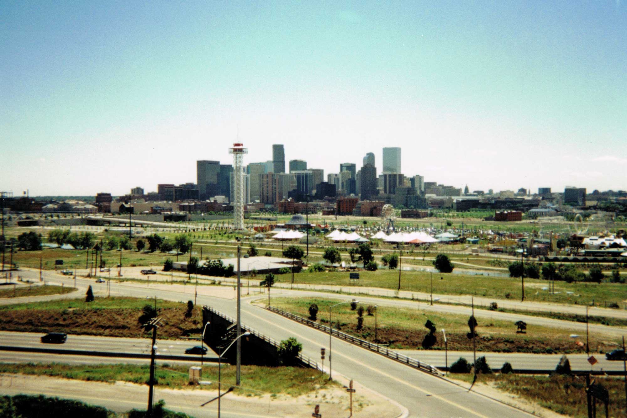
I really wanted to keep my photo-every-twelve-years streak alive, so I looked through my photo albums but couldn’t find a Central Platte Valley photo from 1997. Sorry. However, I did find this one I took from I-25 and 23rd Avenue during the summer of 1996. Close enough?
What’s interesting is how immature Elitch Gardens looks. Elitch’s opened in the CPV in May 1995 so at this point the new Elitch’s was only a year old. Coors Field is visible on the left edge of the photo, but there’s no Pepsi Center yet. That wouldn’t break ground until November 1997. In the foreground, Colorado Ocean Journey (now the Downtown Aquarium) had not yet broken ground either. That wouldn’t happen until April 1997.
No new development had occurred yet behind Union Station. It would be three more years before construction on Commons Park would begin. There’s one building in this view that isn’t there anymore and I totally do not remember it at all. It is the dark gable-roofed building immediately behind the blond-brick Postal Annex building, at approximately the location of the Gates building today. It was fairly tall—the peak of its roof is about the same height as the top of the Postal Annex, approximately 60 feet. Does anyone remember anything about that building?
If we were to do another 12 years, that would put us at 2008/2009, which is basically what we have today, so I won’t bother. But you could always peruse the DenverInfill Blog archives for photos of the Central Platte Valley and Auraria from those years. I’m sure you’ll find a few.


Isn’t that the Terracentre on the far right of the photo?
Yes, I believe it is.
wow! this is only a year before i moved to denver and i cannot believe the amount of low and mid-rise construction that has gone on since then. certainly an improvement.
I’m not sure exactly what that gabled building is, but it appears to be the same one seen in both the 1961 and 1973 photos in relatively the same area. In those photos it is a white-colored building. You can see it in 1973 sandwiched between the 16th and 15th street viaducts to the left of the photo. In the 1961 photo it appears just to the right of the Daniels and Fisher tower. The 1961 photo has a better view.
To me it looks like some kind of grain elevator since a lot of those buildings have that kind of pointed roof sticking out. The building doesn’t appear to have windows except for the bottom two floors, the rest presumably for storage or something. Perhaps by 1996, the building had been abandoned for some time and had darkened and decayed. It certainly would make sense to have grain storage at an area so close to the train tracks like that. Maybe a trip to the Western History Library could clear things up.
Also so sad about the Terracentre. I always liked the building, but I guess it was worth sacrificing it for a world-class convention center.
Sorry…but it looks like I misread the 1973 photo. The building I am talking about is actually between Speer and 15th. It looks like it’s just to the south of the train tracks. In that case, I think it would be located approximately where the Museum of Contemporary Art and the surrounding condos on block C1-1 are currently. (https://denverinfill.com/union_station.htm#C1-1%20(C)).
THe Elitch Gardens redo was a miss step on many levels. The “tower” is not an icon for the city but more of an eyesore. It could have been a really fun park if it was done right. Anyway a lot has changed and for the better. Thanks for posting.
Monarch Mills is named after a mill that burned down on the site – could the gabled building be the old mill?
That could be why the building was “darkened.” A big ‘ole fire will do that.
Ken, thanks for the trip down memory lane. In the summer of ’96 I was working as a bartender at what is now the VQ hotel, the circular tower in the north end of the Mile High parking lots. In those days I believe it was a Radisson? It’s been so long. In any case, the bar is on the top floor, so I was afforded almost this exact view (a little to the right, and a bit higher). I was there when the Avs won their first Stanley Cup. I also used to pass the time watching thunderstorms over the plains, or the bungee ride (name?) at Elitch’s. It is something to be reminded just how different the view was back then with no Pepsi Center and no CPV redevelopment.
Unfortunately I have no recollection of the gabled building.
I think you’re right, Julio, it’s almost exactly where the MCA is now, on the SW corner of 15th and Delgany. It shows on Google Earth’s 1993 historical imagery.
Also, speaking of immature, check out the South Platte Greenway with all its trees still staked and ground cover in neat rows. 🙂
A quick search in photoswest reveals this image from 1930:
http://photoswest.org/cgi-bin/imager?10029113+X-29113
Big sign painted on it, but hard to read… ADY and CROWE? Granaries?
I opened it up with some photo editing software. It looks like it says “Grains & Beans.” I still can’t read what is in the middle though.
If you go to the photo terminals on the fifth floor of the DPL (inside the main reading room, through the security gates, and then take a hard right before you enter the big round room) you can access a higher-res version. Or you can wait until DPL updates their website, planned some time soon (not sure when) when higher-res will be available online.
RE: The Terracenter: The Terracenter, from what I can see in this photo, would be too far to the right to be within this photo, based on the Tivoli Building (blue roof). The Terracenter was mostly concrete with a narrow band of windows on the upper floors, and the tall buildings to the right of the Tivoli Building look to be more “glass curtain walled” than concrete. I worked for the ownership of that building doing the tenant finish in there, up until two or three years before it was demolished.
Bob, at first I thought it would be too far to the right to be Terra Center too, but then I checked it out using GoogleEarth. I took the photo from Riverside Baptist’s bell tower at 23rd & I-25, and if you draw a straight line from that location to the corner of Stout and Speer (Terra Center’s former site), the line passes right over the Tivoli.
Speaking of Terracenter, in my photo albums I found several good photos of it (and Currigan Hall and the “old” Colorado Convention Center). Perhaps I should scan them and post them.
Yes, please.
Back in 1995, there was a movie made in Denver called “Things to Do in Denver When You’re Dead”.
http://www.imdb.com/title/tt0114660/
To see a photo of the old “dark, gable-roofed building,” go to http://www.denverphotoarchives.com/denver_museum_of_contemporary_art.html, and under “MCA 1” click the forward arrow a few times. There are a couple of photos of it in the set. I had forgotten all about it too, but I remember it now. If you’re unfamiliar with this website, there are a lot of great images from 20 or so years ago. How things have changed.
That’s definitely the Terracentre at the far left. From this angle it always appeared very wide, because of the obtuse angle Speer makes with Stout at that location. I worked on the second floor of that building in the early 1990s. Very isolated from downtown–I was the only one in the office who regularly left for lunch, walking past the convention center, etc., to get to 16th.
Yes ideed – from glancing at the photos supplied by MarkB the gable-roofed building is Monarch Mills. The first photo shows that the old mill sat approximately where the townhomes are on Delgany next to the MCA.
All these old photos make me think of how I perceived Denver as I grew up in Boulder. Denver seemed to be a long way from home – mostly a place to visit museums and the State Capitol and the U.S. Mint – but not really a place to enjoy visiting just for fun. (This covers the period 1973-1987, roughly.)
I think the main reason for this lack of attractiveness was because there used to be such a wasteland feeling between I-25 and Downtown. It was all either industrial or abandoned. When we drove in from Boulder, it seemed as if there was no connection between the city and the freeway; instead you had to cross a sort of purgatory to get to the cultural facilities.
My impression of Denver was frozen in this state from about 1987, when I went away to college.
So when I moved back to Colorado in 2004 and began working in Denver, the city surprised me. And I think a lot of that surprise came from what was built between 1988 and 2004, and how the city began to stitch itself back together and re-develop the whole swath of land between the city and I-25.
The gabled building is the Ady & Crowe Mercantile Co./Farmers Grain and Bean Association. It was part of a complex that sat at 15th and Delgany Streets.
George Ady and Patrick Crowe were two guys from Leadville who opened a grain and produce center at this site around 1900. The tall gabled grain elevator portion was built in the summer of 1910.
Most of the complex burned to the ground in December 1993. The grain elevator was the only survivor, but it was pretty blackened up. I think it came down in 1997 (by 2000 it was a parking lot).
Thanks, Joe.